March 11th, 2026
Improved
This update brings improvements to both map sharing and marker icon selection, making it easier to collaborate on maps and quickly find the right icons for your points.
What’s new
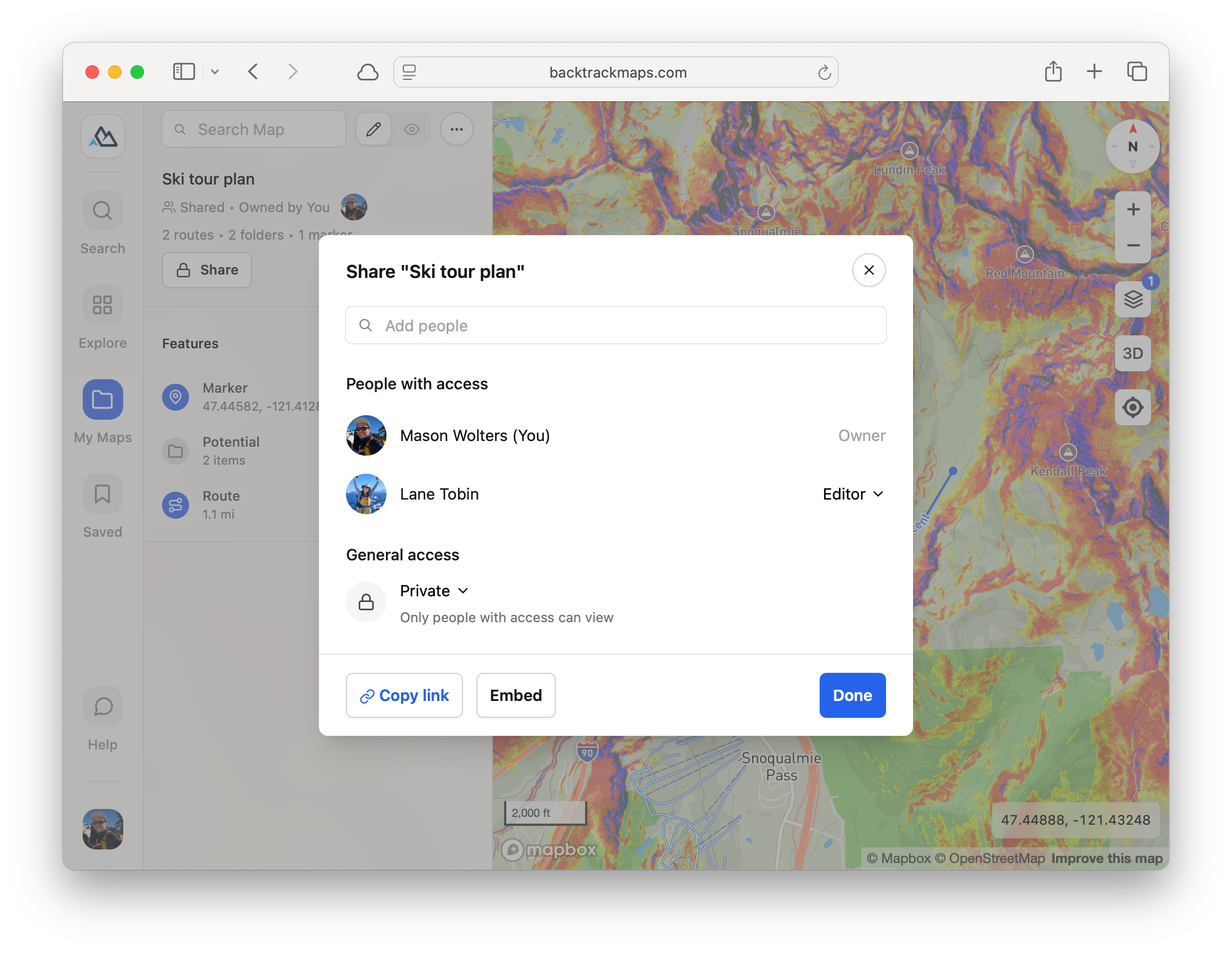
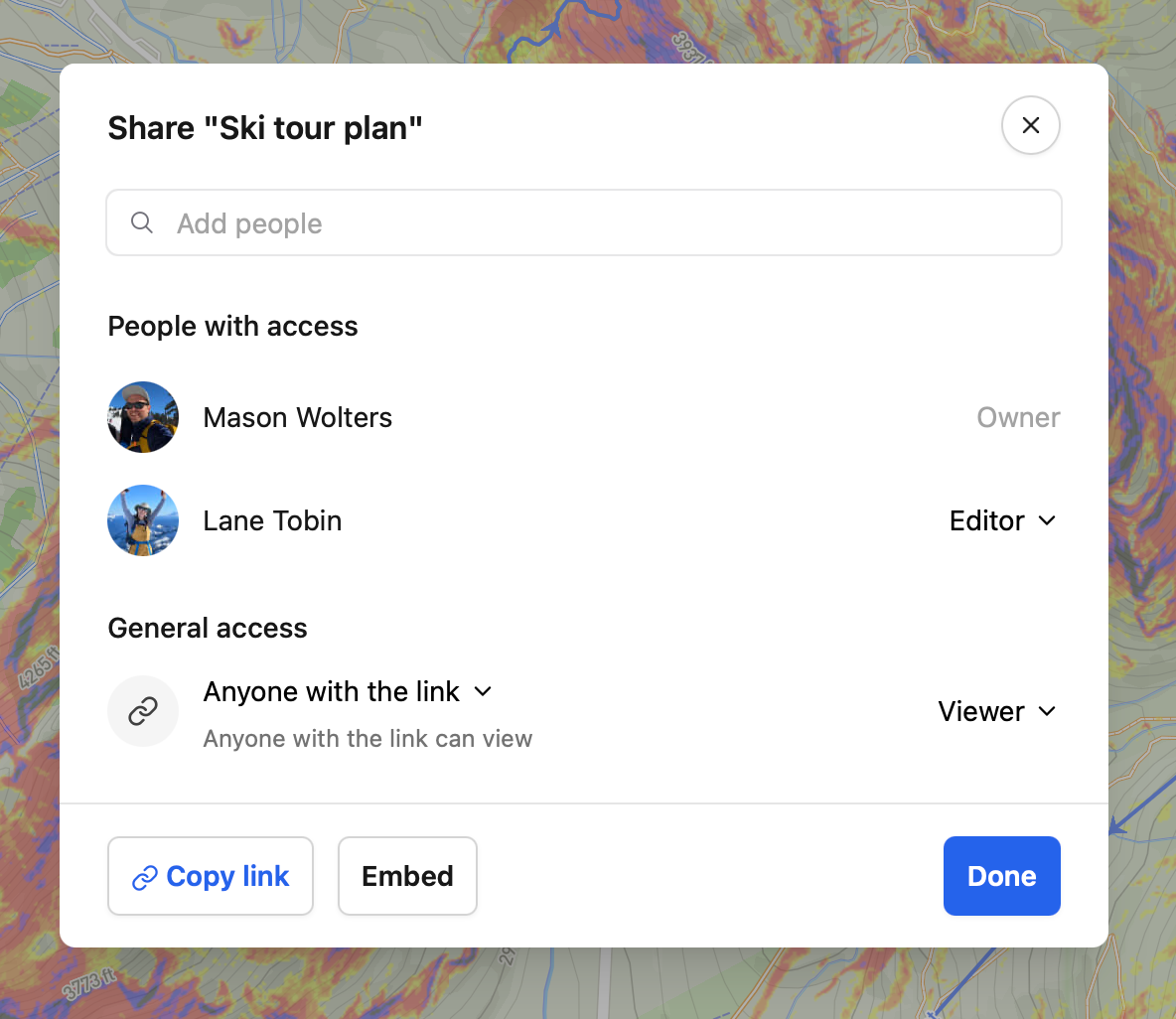
More flexible map sharing
You can now share maps with specific users, not just broad visibility settings.
Set per-user permissions such as View only or Editor.
This allows sharing a map link with general view-only access, while allowing a specific subset of collaborators to edit.
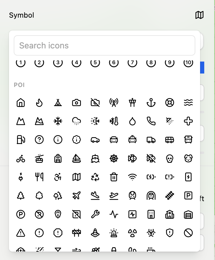
More icons for markers and improved picker
Expanded the marker icon library with many new options, including safety, hazard, activity, and transport icons.
Added search bar so you can easily find the icon you’re looking for.
Other improvements
You can now search the map by latitude + longitude coordinates.
Maps with header images or descriptions will now display those on desktop, matching the mobile experience.
Many of these improvements came directly from feedback in the new Backtrack Discord community. If you have ideas, feature requests, or things that could work better, we’d love to hear them. Join the Discord to chat with the team and community, or submit your ideas to our public feedback board. Your input helps shape what we build next.
November 20th, 2025
New
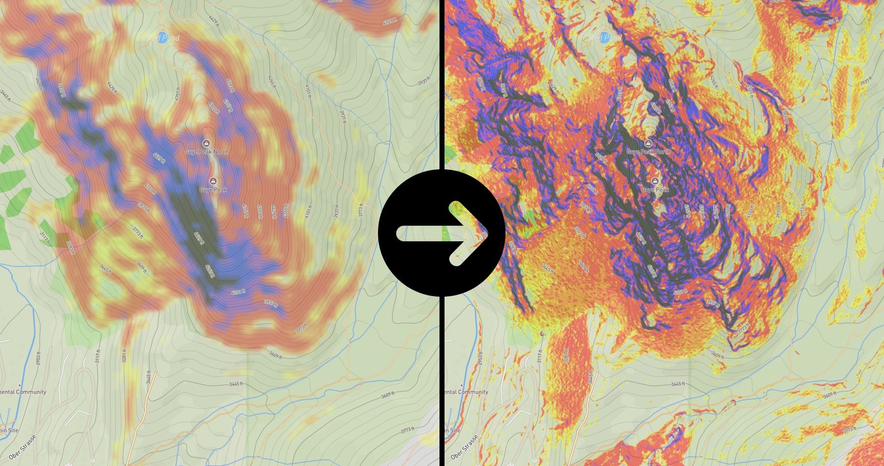
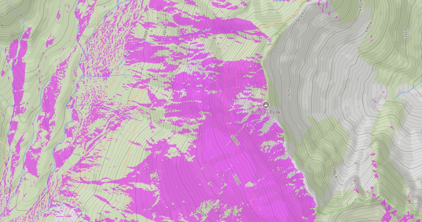
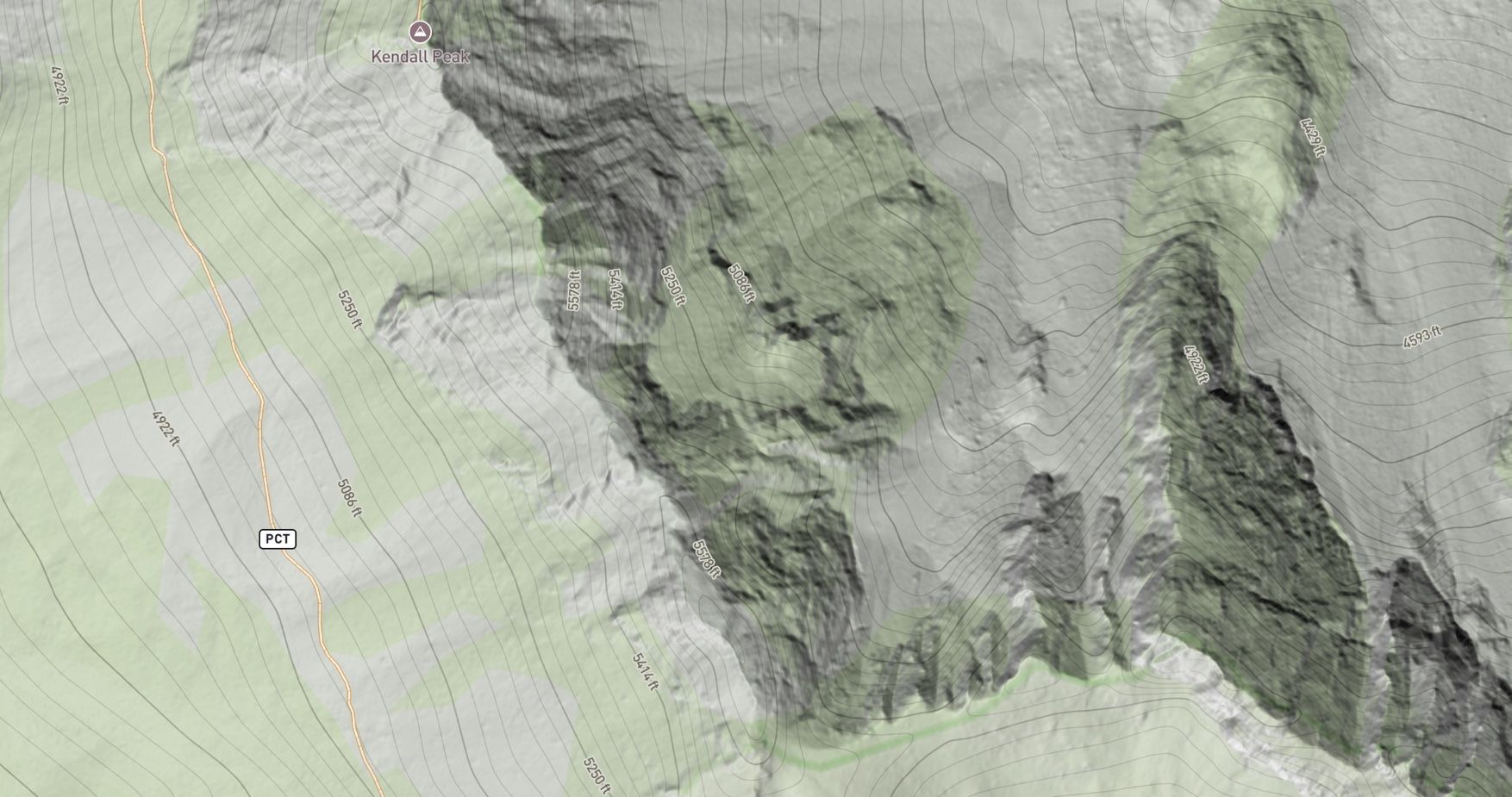
All terrain layers have been rebuilt using high-resolution LiDAR data (1m), increasing the level of detail by over 10x.
New overlays—including Aspect, Hillshade, and Slope Highlight—expand your toolkit for understanding terrain.
The following layers are brand new on the mobile app:
Aspect Shading: Visualize terrain orientation with new aspect shading overlay.

Slope Angle Highlight: New overlay to highlight specific slope angle ranges to identify terrain steepness relevant to your activity.
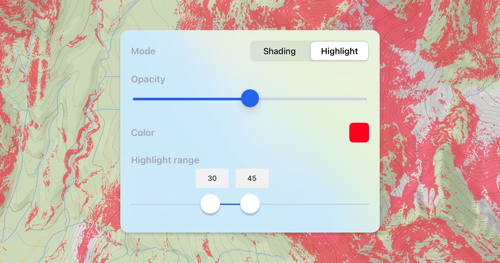
Aspect Highlight: Highlight customizable aspect ranges to zero in on terrain facing the direction you care about.
Hillshade Layer: A new hillshade layer provides realistic shading and enhances terrain readability across all zoom levels.
April 9th, 2025
New
We’re thrilled to announce that Backtrack is now available on the Google Play Store! 🎉
Android users can now plan and share their outdoor adventures—right from their phones. Whether you’re hiking, biking, skiing, or just exploring, Backtrack gives you the tools to map your journey and discover public routes from the community.
What you can do with Backtrack on Android:
• 🌲 Discover maps shared by others
• ✏️ Create and edit custom maps
• 🔍 Access terrain, satellite, and other advanced layers
• 📡 Use offline maps in the backcountry (with Backtrack Pro)
We can’t wait to see where your adventures take you.
February 2nd, 2025

You can now embed your Backtrack maps directly on your own website! 🖥️📍
• Showcase your adventures, routes, or trip plans anywhere.
• Easily share interactive maps with your audience.
• Works seamlessly on blogs, trip reports, and more.
Try it out today and bring your maps to life! 🚀✨
Access from the share modal:

February 2nd, 2025
Improved
🆕 Fullscreen & Easier Navigation!
• High-Resolution Fullscreen View – Immerse yourself in stunning Mountain View panoramas like never before.
• Seamless Panorama Navigation – Use the new arrow buttons to effortlessly explore connected views.
Try it out now! ⛰️🔍
January 15th, 2025
New

We’ve added new map layers:
USGS Topo (National Map)
USGS Imagery Topo
Thunderforest Outdoors
Esri World Imagery
October 1st, 2024
New

Backtrack is no longer just a ski app—it’s now a fully-featured mapping platform built for all your backcountry adventures. With Version 2, you can create, share, and explore maps like never before—plus, we’ve added a desktop app for even better trip planning.

🗺️ Create & Share Your Own Maps
• Plan your own routes and share them with friends.
• Easily import your existing data from Caltopo or Gaia.

💻 Desktop App Now Available!
• Build and edit maps at backtrackmaps.com.
• Changes sync instantly across all your devices.
• Take your maps offline on mobile for on-the-go navigation.

📡 More Powerful Map Layers
• Stack & adjust transparency for better visualization.
• New layers include:
✅ Observations heatmap
✅ Public lands boundaries
✅ Cell coverage maps
✅ …and more!
Start mapping your next adventure now! ⛰️✨
March 15th, 2023
New

Follow the Sun
The sun exposure overlay is a brand new feature designed to help you plan your tour around where the sun shines (or doesn't!).
Adjust the slider to any date and time to see which slopes receive sunlight.
How to Use
The sun exposure layer can be enabled in the map overlay screen. Requires subscription to Backtrack Pro. Works on iOS only, android coming soon.
February 15th, 2023
New

We've added over 275 backcountry routes in the Salt Lake zone of Utah, complete with photos and mountain view.
January 18th, 2023
New

The power of Street View, brought to the mountains
See the terrain like never before with 360º high resolution aerial imagery. Discover new lines with marker overlays and identify terrain hazards before you go.
Zoom in for more detail
With over 230 megapixels in each image, zoom in closer to see that couloir in stunning detail. At over 100x the resolution of satellite imagery, see cliffs and features you just can't from anywhere else.
Requires Backtrack Pro subscription. Start your 7 day free trial today.